


2021-11-27_23h20m07_utgtrack-12559

veroarvinberod
User
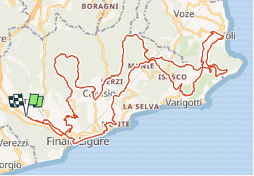

Length
39 km

Max alt
330 m

Uphill gradient
1240 m
Km-Effort
55 km

Min alt
4 m

Downhill gradient
1239 m
Boucle
Yes
Creation date :
2021-11-27 22:20:09.114
Updated on :
2021-11-27 22:20:12.11

FREE GPS app for hiking
 SityTrail
IGN / Geographical institutes
SityTrail Plus
The world is yours!
About
Trail of 39 km to be discovered at Liguria, Savona, Finale Ligure. This trail is proposed by veroarvinberod.
Positioning
Country:
Italy
Region :
Liguria
Department/Province :
Savona
Municipality :
Finale Ligure
Location:
Unknown
Start:(Dec)
Start:(UTM)
445537 ; 4891809 (32T) N.
Comments